Lake Vostok
A team of scientists from Columbia University's Lamont-Doherty Earth Observatory (LDEO) and Rensselaer Polytechnic Institute has published the first map of water deep in Lake Vostok, which lies between 3,700 and 4,300 meters below Antarctica's continental ice cover.
The new measurements of the lake - which is about 14,000 square kilometers in size - indicate that it is divided into two distinct basins that may possess different water chemistry and other characteristics. The discovery has important implications for the diversity of microbial life, and suggests strategies to study the different ecosystems of the lake in order to avoid contamination of this primordial environment.
Michael Studinger and colleagues argue that the existence of two distinct regions may have significantly affected the ecosystems that scientists expect to find in the lake. "The exchange of water between the two systems - explains Studinger - could be limited and, consequently, the chemical and biological composition of the two parts is probably different".
The new maps were published in the June 19 issue of the journal "Geophysical Research Letters". The study, funded by the National Science Foundation (NSF), was carried out using laser altimeters, ice-penetrating radar, and gravity measurements from aircraft.
The secrets of Lake Vostok – Why is the US hiding them?
Antarctica is the most remote continent, the most difficult to access and the most extreme climate (down to -89.2 degrees Celsius!).
For six months of the year, it remains in complete darkness, while during the austral summer, a pale sun shines near the horizon. Not counting the ice sheet, the Antarctic lands extend for a total of 14 million square kilometers (Antarctica is therefore the fifth continent in the world by extension).
Although the very existence of Antarctica had been hypothesized since ancient times, and represented in various maps of the Middle Ages under the name of Terra Australis Incognita, the continent was sighted for the first time only on January 27, 1820 by the officer of the Imperial Russian Navy Fabian Gottlieb von Bellingshausen, while the first man to set foot there was the Anglo-American John Davis, February 7, 1821.
In 1908, the United Kingdom claimed sovereignty over the portion of Antarctica that extends from the South Pole to the sixtieth parallel and from the meridian 20 west to the meridian 80 west. Subsequently, seven other sovereign nations (New Zealand, France, Australia, Nazi Germany, Norway, Chile, Argentina), presented official requests to international bodies to obtain sovereignty over as many portions of Antarctica (Nazi Germany's claim to the land called New Swabia, lost all value following the outcome of the Second World War).
Strangely, the Soviet Union (and later the Russian Federation), and the United States of America, although a Russian and an Englishmanif naturalized Americans were, respectively, the first to sighted Antarctica and the first to set foot there, they have not so far made official claims on portions of Antarctica, but have limited themselves to declaring that they reserve the right to do so in the future.
Antarctic territorial claims, however, do not include the whole continent. Marie Byrd's Land (1.6 million square kilometers wide, more than five times the size of Italy), explored by the American Richard Byrd in 1929, has never been claimed by any sovereign state. Because?
The crucial date of the exploration of Antarctica was December 1911 when the Norwegian Roald Amundsen reached the South Pole in a daring expedition.
Explorers are usually always sent by the secret services of the States, and often have the purpose of identifying areas suitable for mining exploitation and strategic from a military point of view. After the end of World War II, some sovereign states established bases in Antarctica, officially for scientific reasons.
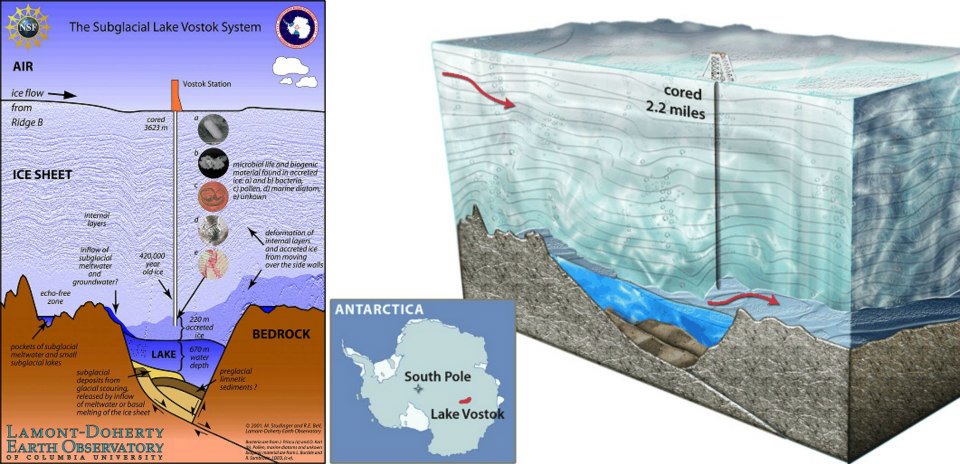
The Soviet Union built a base located at the coordinates 78 degrees 27' South and 106 degrees 50' East, and named it Vostok (East, in Russian).
Today the Vostok station, located at 3488 meters above sea level (exactly above an ice sheet of over 3600 meters), is the most isolated of the 67 scientific stations (belonging to 30 different states), which currently exist in Antarctica, and is supplied by the Mirny station, on the Antarctic coast.
In 1970, following radar surveys carried out by means of aircraft, the Russians declared that their base had been built by chance in the exact place where, 3623 meters below, the largest subglacial lake in the world was located, which was also baptized Vostok.
Very strange: in fact, if you consider that the surface of Antarctica is 14 million square kilometers, and that the lake is about 14,000 square kilometers large, the probability of fortuitously building the base at the exact point where 3623 meters below the lake rises, is one in 1000!
It must be remembered that there are about 140 subglacial lakes in Antarctica, but Vostok is certainly the largest and also the most mysterious.
Lake Vostok, which contains liquid water, is 250 kilometers long and about 60 kilometers wide. The total volume of water contained in it amounts to 5400 cubic kilometers (this would be enough for the water consumption of as many as 50 million people for three years, calculating one hundred liters per day per person!).
Among the various mysteries that Lake Vostok hides there is also the altitude above sea level of the bottom of the lake itself: if we consider the data of the Scientific Committee on Antarctic Research, the surface of the lake is located 3623 meters below the Vostok base, which in turn is located 3488 meters above sea level.
The surface of the lake would therefore be located 135 meters below the average sea level and, since the maximum depth is 800 meters (average depth 670 meters), the bottom of the lake would be 935 meters below the average sea level.
According to official data, the temperature of the water of the lake would be -3 degrees Celsius, and the liquid form of the water of the lake would be stillThe enormous pressure caused by the ice cap. Other sources indicate that in some parts of the lake the temperature of 19 degrees Celsius would be reached, and this indicates that there is probably strong geothermal activity below the lake.
There are currently controversial opinions about how old the ice sheet above Lake Vostok is. While some scientists point to an antiquity of 420 millennia, other researchers argue that the ice cap was formed only 13 millennia ago.
In 1998, Russian, American and French scientists drilled into the icy crust to about 120 meters above the surface of the lake, ostensibly to avoid contaminating it. There have also been subsequent drillings (2008 and 2009), but none has pierced the ice cap to date up to the lake. Analysis of the recovered ice indicated traces of methane, bacteria, pollen remnants, marine multicellular and other residues of unknown multicellular beings. Studies have concluded that Lake Vostok is a super-saturated oxygen-saturated environment (the oxygen concentration could be 50 times higher than a normal surface lake). These factors have so far convinced scientists not to completely pierce the ice cap, as once opened, bacteria capable of contaminating the surrounding environment, completely unknown until now, could arise from the lake.
The latest news, from February 2010, reports that the Russian scientist Valerie Lukin, head of the Russian expedition to Antarctica, says she is ready to send a probe inside the lake by 2012. The probe would be sterile, so as not to contaminate the sub-glacial environment. Lukin says it will be possible to study living microorganisms that date back hundreds of millennia.
Starting in 2001, a group of US scientists began flying over Lake Vostok at low altitude, with the aim of studying the magnetic activity that occurs at the lake. During these overflights, a powerful magnetic anomaly was discovered in the southeastern area of the lake. The discrepancy has been calculated in 1000 nanotesla, a huge amount, the causes of which are unknown. Another characteristic of the anomaly is its extraordinary size: it extends for 166 square kilometers.